
Turkey is generally divided into seven regions; the Black Sea region, the Marmara region, the Aegean, the Mediterranean, Central Anatolia, the East Anatolian and Southeast Anatolia regions. The uneven north Anatolian terrain running along the Black Sea resembles a narrow but long belt. The land of this region is approximately one-sixth of Turkey's total land area.
The Marmara region covers the area encircling the Sea of Marmara and includes the entire European part of Turkey, as well as the northwest of the Anatolian plain. Whilst the region is the smallest of the regions of Turkey after the Southeast Anatolia region, it has the highest population density of all the regions.
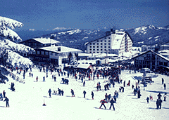
| The most important peak in the region is Uludag (2,543 metres), a
major winter sports and tourist center. In the Anatolian part of the
region there are fertile plains running from east to west.
The Aagean region extends from the Aegean coast to the inner parts of western Anatolia. There are significant differences between the coastal areas and those inland, in terms of both geographical features and economic and social aspects. In general, the mountains in the region fall perpendicularly into the sea, and the plains run from east to west. The plains through which the Gediz, Kucuk Menderes and Bakircay rivers flow carry the same names as these rivers. In the Mediterranean region, located in the south of Turkey, the western and central Taurus Mountains suddenly rise up behind coastline. The Amanos mountain range is also in the area. The Central Anatolian region is exactly in the middle of Turkey and gives the appearance of being less mountainous compared with the other regions. The main peaks of the region are Karadag, Karacadag, Hasandag and Erciyes (3,917 metres). The Eastern Anatolian Region is Turkey's largest and highest region. About three-fourths of it is at an altitude of 1,500-2,000 meters. Eastern Anatolia is composed of individual mountains as well as of whole mountain ranges, with vast plateaus and plains. There are numerous inactive volcanoes in the region, including Nemrut, Suphan, Tendurek and Turkey's highest peak, Mount Agri (Ararat), which is 5,165 meters high. Several plains extend along the course of the River Murat, a tributary of the Firat (Euphrates). These are the plains of Malazgirt, Mus, Capakcur, Uluova and Malatya. The Southeast Anatolia region is notable for the uniformity of its landscape, although the eastern part of the region is comparatively more uneven than its western areas.
|

Uludag, at 2,543 meters, is the most
Mount Agri (Ararat) |
![]()
Home | Ana
Sayfa | All About Turkey | Turkiye
hakkindaki Hersey | Turkish Road Map
| Historical Places in Adiyaman | Historical
Places in Turkey | Mt.Nemrut | Slide
Shows | Related Links | Guest
Book | Disclaimer | Send a Postcard | Travelers' Stories | Donate a little to help | Getting Around Istanbul | Adiyaman Forum
|
|