
Karakoy
Go Back to Istanbul Subway Main Page
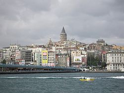
Karaköy, the modern name for the ancient Galata, is a commercial neighborhood in the Beyoğlu district of Istanbul, Turkey, located at the northern part of the Golden Horn mouth on the European side of Bosphorus.
Karaköy is one of the oldest and most historic districts of the city, and is today an important commercial center and transport hub. The location is connected with the surrounding neighborhoods through streets originating from Karaköy Square. The Galata Bridge links Karaköy to Eminönü in the southwest, Tersane Street to Azapkapı in the west, Voyvoda Street to Şişhane in the northwest, the steeply sloping Yüksek Kaldırım Street to Beyoğlu in the north, Kemeraltı Street and Necatibey Street to Tophane in the northeast.
The commercial quarter, which was originally the meeting place for banks and insurance companies in the 19th century, is today also home to mechanical, electrical, plumbing and electronic parts suppliers.
Karaköy has been a port area since Byzantine times when the north shore of the Golden Horn was a separate settlement, walled across Golden Horn from the Old City. Around the year 1000, the emperor of Byzantium granted to the merchants of Genoa the permission to settle and do business at this location.
The district developed rapidly, and the Genoeses built sturdy fortifications to protect themselves and their warehouses. Fragments of the Genoese walls are still visible, but the Galata Tower, the highest and strongest point in the walls, is the most visible of all. In the 15th century, Galata looked just like an Italian city.
In 1455, right after the conquest of Constantinople, the district had three categories of inhabitants: temporarily sojourning Genoese, Venezian and Catalan merchants; Genoese of Ottoman citizenship; and Greeks, Armenians and Jews. The composition of the population changed in a short time, and according to a census of 1478, almost half of the district population was Muslim. From 1500 on, more Sephardic Jews settled here, who escaped from the Spanish Inquisition.
Karaköy experienced a second wave of Christian inflow when British, French and Italian forces of the Allies came to Istanbul to fight in the Crimean War (1854-1856). The lack of piers made the unloading of troops and military equipment difficult. A French company obtained 1879 the consession to build the quay in Karaköy, which could be accomplished in 1895 only
In the last decade of the 19th century, Karaköy developed itself to a banking district. The Ottoman Bank established here its headquarter, Italian and Austrian insurance companies opened branch offices.
With the increasing trade activity in the early 20th century, the port was extended with customs buildings, passenger terminals and naval warehouses. Karaköy became also famous for its Greek taverns located along the quays.
After 1917, thousands of White Russians fleeing the Bolshevik Revolution landed here and settled in the area.
Karaköy is today a major transport hub for intercity and international passenger traffic.
The Galata Bridge connects Karaköy with the Old City, on which the fast tram line Zeytinburnu-Kabataş runs. The underground funicular, called Tünel, has been transferring people from its lower end in Karaköy upwards to Istiklal Avenue in Beyoğlu since 1876. Ferry boats run every 10 to 20 minutes from the ferry terminal on a pontoon to Haydarpaşa train terminal and Kadıköy across the Asian shore of Bosphorus.
From the Port of Karaköy, ferries operate to destinations at Black Sea such as Odessa, Yalta, Sevastopol, Kherson, Eupatoria, Novorossisk in Ukraine and Constanţa in Romania. Huge luxury cruise ships sailing to Mediterranean ports such as Athens in Greece, Dubrovnik in Croatia , Civitavecchia (Rome) and Venice in Italy berth also at the Karaköy port.
An active business center for centuries, Karaköy remains an important commercial center of Istanbul. All kinds of hardware, mechanical tools and parts are offered in Perşembe Pazarı (literally Thursday Market) around the Tersane Street. Shops selling electrical items are located in the Voyvoda Street. Various plumbing articles can be found around Kemeraltı Street. Selanik Pasajı, a shopping center right on the Karaköy Square, hosts shops specialized in electronic parts. An underground market provides also safe passage under the busy road crossing the Karaköy Square.
Karaköy is also a popular place to eat especially seafood, börek (pastry), muhallebi (Turkish pudding) and baklava. Numerous tiny fish restaurants, pubs and cafés located under the Karaköy side of the Galata Bridge roadway attract local and foreign tourists. Liman Lokantası (the Port Restaurant), situated in the passenger terminal building, is a renowned place to dine.
Istanbul's red-light district is found also in Karaköy.
The presence of various religious and educational sites in Karaköy such as Latin Catholic, Greek Orthodox, Armenian and Bulgarian churches, Jewish synagogues, and Greek, Jewish, French, Italian and Austrian schools as well reflect its historic cosmopolitan character. A wealth of architectural monuments can be found in Karaköy, left by the European communities that thrived here during the Ottoman period.
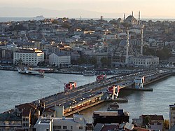
The Galata Bridge (in Turkish Galata Köprüsü) is a bridge that spans the Golden Horn in Istanbul, Turkey. From the end of the 19th century in particular, the bridge has featured in Turkish literature, theater, poetry and novels.
The oldest recorded bridge over the Golden Horn in Istanbul was built during the reign of Justinian the Great in the 6th century close to the area near the Theodosian Land Walls at the western end of the city. In 1453, during the Fall of Constantinople, the Turks assembled a mobile bridge by putting their ships next to each other and used it for transporting their troops from one side of the Golden Horn to the other.

In the years 1502–1503 plans to construct the first bridge in the current location were discussed. Sultan Bayezid II solicited a design and Leonardo da Vinci, utilizing three well-known geometrical principles, the pressed-bow, parabolic curve and keystone arch, created an unprecedented single span 240 m long and 24 m wide bridge for the Golden Horn, which would become the longest bridge in the world of that period if constructed. However, the ambitious design did not meet with the Sultan's approval. Another Italian artist, Michelangelo was also invited to design a bridge for Istanbul. Michelangelo rejected the proposal, and the idea of building a bridge across the Golden Horn was shelved until the 19th century.
A smaller scale version of Leonardo da Vinci's Golden Horn Bridge was brought to life in 2001 near Oslo, Norway by the contemporary artist Vebjørn Sand, the first civil engineering project based on a Leonardo da Vinci sketch to be constructed. The Leonardo Bridge Project hopes to build the design as a practical footbridge around the world, including the Golden Horn in Istanbul, using local materials and collaborating with local artisans as a global public art project. The Wall Street Journal referred to the Project as a "...logo for the nations." (WSJ, Nov. 5-6, 2005)

In the early 19th century Mahmud II (1808-1839) had a bridge built at some distance up the waterway between Azapkapi and Unkapani. This bridge, known as the Hayratiye (Benefaction in English), was opened on September 3, 1836. The project was carried out by Deputy Lord High Admiral Fevzi Ahmet Pasa using the workers and facilities of the naval arsenal. According to the History of Lutfi, this bridge was built on linked pontoons and was around 500 to 540 m long.
The first Galata Bridge at the mouth of the waterway was constructed in 1845 by Valide Sultan, the mother of Sultan Abdulmecid (1839-1861) and used for 18 years. It was known as the Cisr-i Cedid or New Bridge to distinguish it from the earlier bridge further up the Golden Horn, which became known as the Cisr-i Atik or Old Bridge.
On the Karaköy side of the bridge, there was an inscription as a couplet by poet Sinasi saying that the New Bridge was built by Abdulmecid Han. First to pass over the bridge was Sultan Abdulmecid, and the first to pass below it was the French captain Magnan in his ship the Cygne.
For the first three days crossing the bridge was free, after which a toll known as mürüriye was paid to the Naval Ministry. Toll collecting started on November 25, 1845 and the toll was charged:
Toll was collected until May 31, 1930 by officials in white uniform standing on both ends of the bridge.
This bridge was replaced by a second wooden bridge in 1863, built by Ethem Pertev Pasa on the orders of Sultan Abdulaziz (1861-1876) in readiness for the visit of Napoleon III to Istanbul.

In 1870 a contract was signed with a French company, Forges et Chantiers de la Mediteranée for construction of a third bridge, but the outbreak of war between France and Germany delayed the project, which was given instead to a British firm G. Wells in 1872. This bridge, completed in 1875, was 480 m long and 14 m wide and rested on 24 pontoons. It was built at a cost of 105,000 gold liras. This was used until 1912, when it was pulled upstream to replace the now genuinely old Cisr-i Atik Bridge.
The fourth Galata Bridge was built in 1912 by the German firm MAN AG for 350,000 gold liras. This floating bridge was 466 m long and 25 m wide. It is the bridge still familiar to many people today that was badly damaged in a fire in 1992 and towed up the Golden Horn to make way for the modern bridge now in use.

The fifth Galata bridge was built by the Turkish construction company STFA just a few meters away from the previous bridge, between Karaköy and Eminönü, and completed in December 1994. It was designed and supervised by GAMB (Göncer Ayalp Engineering Company). It is a bascule bridge, which is 490 m long with a main span of 80 m. The deck of the bridge is 42 m wide and has three vehicular lanes and one walkway in each direction. It has also recently had tram tracks added to it, allowing the Istanbul Tram to run from Zeytinburnu in the suburbs near Ataturk International Airport to Kabataş, a few blocks before Dolmabahçe Palace. This bridge, Trowse Bridge in Norwich, and a number of rail bridges in the United States may be the only movable bridges in the world which also carry electrified rail tracks.
It is a common argument that the bridge was not designed for this modification, which was added later as a necessity. Laymen had to make inspections of the bridge due to several engineering problems, which caused a setback of many years because of the discord between the supervisor and the contractor. The rest of the bridge including the market area in the first floor opened to common use in 2003.
The Galata Bridge was a symbolic link between the traditional city of Istanbul proper, site of the imperial palace and principal religious and secular institutions of the empire, and the districts of Galata, Beyoğlu, Şişli and Harbiye where a large proportion of the inhabitants were non-Muslims and where foreign merchants and diplomats lived and worked. In this respect the bridge bonded these two distinctive cultures. As Peyami Safa wrote in his novel, fatih-Harbiye, a person who went from fatih to Harbiye via the bridge set foot in a different civilization and different culture. Apart from its place in fiction, the romantic appearance of the Galata Bridge made it the subject of many paintings and engravings.
All daily city tours in Istanbul include this bridge as it is the passageway to the Old City of Constantinople.


The Galata Tower (Turkish: Galata Kulesi), also called Christea Turris (Tower of Christ) by the Genoese and Megalos Pyrgos (The Great Tower) by the Byzantines, is located in Istanbul, Turkey, to the north of the Golden Horn. One of the city's most striking landmarks, it is a huge, cone-capped cylinder that dominates the skyline on the Galata side of the Golden Horn.

The tower was built as Christea Turris in 1348 during an expansion of the Genoese colony in Constantinople. It was the apex of the fortifications surrounding the Genoese citadel of Galata. The current tower should not be confused with the old Tower of Galata, an original Byzantine tower, named Megalos Pyrgos, which controlled the northern end of the massive sea chain that closed the entrance of the Golden Horn. This tower was on a different site and was largely destroyed during the Fourth Crusade in 1204.
The nine-story tower is 66.90 meters tall (62.59 m without the ornament on top, 51.65 m at the observation deck), and was the city's tallest structure when built. The elevation at ground level is 35 meters above sea-level. The tower has a diameter of 16.45 meter at the base, with 8.95 meters diameter inside, and with walls 3.75 meters thick.
The upper section of the tower with the conical cap was slightly modified in several restorations during the Ottoman period when it was used as an observation tower for spotting fires.
According to the Seyahatname of Ottoman historian and traveller Evliya Çelebi, in circa 1630-1632, Hezarfen Ahmet Çelebi flew as an early aviator using artificial wings for gliding from this tower over the Bosporus to the slopes of Üsküdar on the Anatolian side. Evliyâ Çelebi also tells of Hezarfen's brother, Lagari Hasan Çelebi, performing the first flight with a rocket in a conical cage filled with gunpowder in 1633. The exploits of the brothers were also mentioned by John Wilkins in his Discovery of a World in Moone in 1638.
In the 1960s the original wooden interior of the tower was replaced by a concrete structure and it was opened to the public. There is a restaurant and café on its upper floors which commands a magnificent view of Istanbul and the Bosphorus. Also located on the upper floors is a nightclub which hosts a Turkish show. There are two operating elevators that carry visitors from the lower level to the upper levels. Entrance to the tower costs 10 YTL (New Turkish Lira).
![]()
Go Back to Istanbul Subway Main Page
Hop On Hop Off City Sightseeing Istanbul - City Tour - Ho Ho Points
![]()
Home |
Ana
Sayfa | All About Turkey |
Turkiye
hakkindaki Hersey | Turkish Road Map
| Historical Places in Adiyaman |
Historical
Places in Turkey | Mt.Nemrut |
Slide
Shows | Related Links |
Guest
Book | Disclaimer | Send a Postcard | Travelers' Stories |
Donate a little to help |
Istanbul Subways |
Adiyaman Forum
|
|