
 The
Southeastern Anatolian Region has a very rich history and cultural heritage, as
can be seen in its magnificent historical sites. Its history begins around 7,000
B.C. in the New Stone Age. Between 2,000 B.C. and 1,500 B.C. came the Hurris who
were followed by the Hittites sometime around 1,200 B.C.
The
Southeastern Anatolian Region has a very rich history and cultural heritage, as
can be seen in its magnificent historical sites. Its history begins around 7,000
B.C. in the New Stone Age. Between 2,000 B.C. and 1,500 B.C. came the Hurris who
were followed by the Hittites sometime around 1,200 B.C.
In the land which encircles the Fırat (Euphrates) and the Dicle (Tigris) rivers, lived Abraham, the patriarch claimed by three world religions. Some think that Abraham was born in what is now called Sanliurfa, supposed to have been Ur of the Chaldees, and later moved south from the city to Harran. In Harran, which was an important Mesopotamian historic and cultural center, the ruins of one of the largest and oldest Islamic universities can be seen among the archaeological remains. Restoration of the 18th-century mansion, Küçük Hacı Mustafa Hacıkamiloglu Konagi in Şanlıurfa, is now complete. It has just reopened and now serves as an art gallery.
When you travel from the south to the north over the Mesopotamian plains, the first high mountain to be seen is the picturesque Mt. Nemrut, with the mausoleum of the Commagene King Antiochos at its 2,150 meter peak.

The most important areas of the region are Diyarbakır, whose city walls are a superb example of medieval military architecture; Mardin with its regional architecture; and Gaziantep, a large trade and industrial center which contains the remains of late Hittite cities.
The Ataturk Dam Lake is the region's holiday and water-sports center. There are many beaches along the shore of the lake which can give you an unforgettable holiday experience under the Mesopotamian sun.
 The
Southeastern Anatolian Project is the largest and most
multifaceted development project in Turkey as well as one of the, largest
development projects in the world. The project includes active farming with
extensive irrigation systems and electricity production. It will also benefit
the tourism, mining, petrol, education, health, communication, industry and
transportation sectors.
The
Southeastern Anatolian Project is the largest and most
multifaceted development project in Turkey as well as one of the, largest
development projects in the world. The project includes active farming with
extensive irrigation systems and electricity production. It will also benefit
the tourism, mining, petrol, education, health, communication, industry and
transportation sectors.
The Southeastern Anatolia Project covers the lower parts of the Fırat and Dicle rivers and
the provinces of Gaziantep, Sanliurfa, Adiyaman,
Diyarbakir, Mardin, Siirt, Batman
and Şırnak, on the plains between the rivers. The
project will also bring with it a change in the climate of the area.
Anatolia Project covers the lower parts of the Fırat and Dicle rivers and
the provinces of Gaziantep, Sanliurfa, Adiyaman,
Diyarbakir, Mardin, Siirt, Batman
and Şırnak, on the plains between the rivers. The
project will also bring with it a change in the climate of the area.
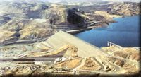
The Atatürk Dam and Hydroelectric Plant, the largest in Turkey and the sixth largest in the world, is situated on the Fırat River in the town of Bozova in Sanliurfa. Ataturk Dam, which is the foundation of the Southeastern Anatolia Project, began operation in 1994 and is important not only for energy production but also for irrigation. The water obtained from the reservoirs of the Ataturk Dam will be carried to the Harran plain by the Şanlıurfa Tunnel System, which is the largest in the world, in terms of length and rate of flow. The waters of the Fırat river will pass through tunnels which are 26.4 kilometers in length and 7.62 meters in diameter, and be distributed to the vast croplands of the southeastern Anatolian plains from central and branch channels, bringing a production boom and prosperity to the region.
back to top
To explore the sites along Turkey's southern border, take the highway which connects Gaziantep, Sanliurfa and Mardin to Syria and Iraq.
Gaziantep (685 km southeast of Ankara) is located on a wide and fertile plain cultivated with extensive olive groves and vineyards and produces a wide variety of agricultural crops. It is especially known throughout Turkey for its excellent pistachios. Industry also contributes to the local economy.
The 36 towers of the city's fortress were originally constructed in the Justinian era and were later rebuilt by the Seljuks. The Archaeology Museum has important artifacts from Neolithic, Hittite and Roman times. The Hasan Süzer House, from the turn of the century, has been beautifully restored as the Ethnographical Museum. The artisans of Gaziantep specialize in copperware and furniture inlaid with mother-of-pearl. The kitchens there produce some of the best lahmacun, a delicious pizza topped with spicy meat and herbs, and also baklava, a honey and nut pastry.
 West
of Gaziantep, the Dülük Forest makes a good day's outing, or you can stay
overnight in the campsite. In the woods, stroll through the archaeological site
which dates back to prehistoric times. A Hittite school of sculpture was centred
in Yesemek, where the 200 works of art still reveal the beauty of
the Hittite period. Next to the Syrian border, on the banks of the Fırat
River, Kargamış, once a late Hittite capital, is another
important archaeological site. The site's finds, including immense bas-reliefs,
have been moved to the Museum of Anatolian Civilizations
in
Ankara.
West
of Gaziantep, the Dülük Forest makes a good day's outing, or you can stay
overnight in the campsite. In the woods, stroll through the archaeological site
which dates back to prehistoric times. A Hittite school of sculpture was centred
in Yesemek, where the 200 works of art still reveal the beauty of
the Hittite period. Next to the Syrian border, on the banks of the Fırat
River, Kargamış, once a late Hittite capital, is another
important archaeological site. The site's finds, including immense bas-reliefs,
have been moved to the Museum of Anatolian Civilizations
in
Ankara.
The ruins of Belkıs (Zeugma) are on the edge of Nizip. There is a mound which was turned into a citadel and mosaics from the Roman period, which are well worth seeing.
Kilis, near the Turkish-Syrian border en route to Gaziantep, was originally known in the Assyrian archives as Kilizi. Kilis is important for its cotton and silk weaving and also for its leather products. This most charming area is dotted with vineyards and olive groves on all sides. Also interesting are the Canbolat Bey complex, the old baths and a center that once housed a dervish order. Several other sites worth seeing nearby include Ravanda Castle, situated between Kilis and Gaziantep. 5 km to the northeast is the town of Kuzeyne (Korus) that is like an open-air museum with its castle and mosaics. What makes it special is that here one can view ruins from Hittite, Roman, Byzantine, and Islamic times all in one place. An ancient Roman center is found 20 km east of Kilis in the town of Korus (Kiriz). Ruins of a castle, a temple and a theatre await your visit.
 In
the 12th century B.C. Kahramanmaras (78 km north of Gaziantep)
was the capital of the Hittite state of Gurgum. A massive citadel
built in the 2nd century B.C. now houses the city museum with a good collection
of Hittite sculptures. Other sites include the 15th-century Ulu Mosque
and the Taş Medrese. The city is famous throughout Turkey for
its ice-cream thickened with gum arabic and beaten with a wooden paddle.
In
the 12th century B.C. Kahramanmaras (78 km north of Gaziantep)
was the capital of the Hittite state of Gurgum. A massive citadel
built in the 2nd century B.C. now houses the city museum with a good collection
of Hittite sculptures. Other sites include the 15th-century Ulu Mosque
and the Taş Medrese. The city is famous throughout Turkey for
its ice-cream thickened with gum arabic and beaten with a wooden paddle.
Adiyaman (153 km northeast of Gaziantep) the Archaeological Museum houses regional finds from the Lower Fırat which date from the Neolithic and Chalcolithic ages. Good quality kilims woven in bright colours sell for reasonable prices in the bazaar. Surrounding monuments include the ruins of an Abbasid citadel (restored by the Seljuks) and the 14th century Ulu Mosque. The discovery of oil in the region has brought prosperity to Adiyaman. 5 km to the north is Pirin (Perre), that boasts a large Roman necropolis dug out of the rock and soil.
 Adiyaman,
as well as Kahta (which also has good accommodation and camping
facilities), make good bases from which to visit Nemrut Dağı
(Mt. Nemrut) National Park. You can hire
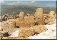
transportation in either town. On the summit of Nemrut Dağı, at 2,150
meters the highest mountain in Northern Mesopotamia, sits the gigantic funerary
sanctuary erected in the first century B.C. by King Antiochos I of Commagene.
The engineering involved continues to amaze visitors seeing for the first time
the artificial tumulus as it is flanked by terraces on which rest the colossal
statues of Apollo, Zeus, Heracles, Tyche
and Antiochus. Time has inflicted heavy damage on the sculptures -
their torsos sit with their beautifully carved heads at their feet.
Adiyaman,
as well as Kahta (which also has good accommodation and camping
facilities), make good bases from which to visit Nemrut Dağı
(Mt. Nemrut) National Park. You can hire
transportation in either town. On the summit of Nemrut Dağı, at 2,150
meters the highest mountain in Northern Mesopotamia, sits the gigantic funerary
sanctuary erected in the first century B.C. by King Antiochos I of Commagene.
The engineering involved continues to amaze visitors seeing for the first time
the artificial tumulus as it is flanked by terraces on which rest the colossal
statues of Apollo, Zeus, Heracles, Tyche
and Antiochus. Time has inflicted heavy damage on the sculptures -
their torsos sit with their beautifully carved heads at their feet.
At ancient Eskikale (Arsameia of Nymphaios), a magnificent relief in the ruins of what scholars believe might have been the Commagene Palace depicts Heracles greeting the Commagene king, Mithradates. Opposite this site, separated by the Eski Kahta river, are the remains of Yenikale (New Castle) built by the Mamluks. Other nearby sights include the Roman bridge at Cendere and another Commagene royal tumulus, Karakuş.
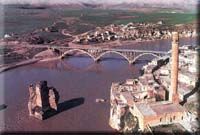
In the great Upper Mesopotamian plain, Sanliurfa, thought by some to be the ancient city of Ur and later known as Edessa, proudly exhibits the legacy of all the civilizations that have prospered in this region. Some of the oldest signs of civilization, dating to 7000 B.C., were found 70 kilometers northwest of Sanliurfa, at the village of Kantara. The recent development of dams and a hydroelectric plant stand in stark contrast to the ancient site of a temple and Neolithic settlement which is nine thousand years old. The temple has been identified as a religious center for moon worship. This site is still the only one of its kind in the world. Visitors can view small idols and religious figures as well as some very early and beautiful mosaic work from the settlement. On a hill 20 kilometers northeast of Sanliurfa lies Göbekli. This settlement is perhaps 9000 years old, and may rest atop even older settlements in lower layers of the artificial hill. The probable workplace of an ancient idol maker can be seen here where many finished and unfinished human and animal figures and tools have been found. The Sanliurfa area, in the second millennium B.C., was a city of a Hurrite state. Some believe that Abraham was born in a cave near where the Mevlid Halil Mosque now stands. Today the cave is a pilgrimage site and flocks of pigeons do not seem to disturb the elderly men praying around the entrance. The remains of a castle with two lone Corinthian columns rising above the ruined walls stands atop a small crest. At the foot of the hills, the lovely Halil Rahman Mosque is built around a quiet pool in which sacred carp swim. The 17th-century Ottoman Rıdvaniye Mosque and the Fırfırlı Mosque, formerly the Church of the Apostles, are worth a detour. The Archaeology and Ethnography museum, one of the best in Turkey, houses important Neolithic and Chalcolithic finds from the Lower Fırat region. To capture the spirit of Şanlıurfa, wander through the vaulted eastern bazaar and linger in the courtyards of the old hans (inns). See if you can find Gümrük Hanı and Barutçu Hanı - the most interesting of the old hans.
Believed, to be the ancient city of the same name mentioned in the Old Testament, Harran is known more now for its unusual beehive dwellings than as the place where Abraham actually spent several years of his life. Included among the archaeological are those of the largest ancient Islamic university, city walls dating from the eighth century, four gates and a citadel. The GAP project will transform Harran into one of the most fertile areas in Turkey.
Birecik, 80 km west of Şanlıurfa, straddles the Fırat river and is dominated by the citadel. A good place to take a break, there are good accommodations and camping facilities here.
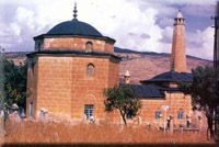
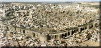 Diyarbakir,
known in ancient times as Amida, spreads across a basalt plateau
close to the banks of the Dicle river. The black basalt triple walls which
encircle the old town give the city a rather ominous appearance. These ramparts
are 5.5 km in length, have 16 keeps and five gates, are decorated with
inscriptions and bas-reliefs, and represent a superb example of medieval
military architecture. The Ulu Mosque, built by the Seljuk sultan Melik Shah, is
notable for its original design and for its utilisation of both Byzantine and
more ancient architectural materials. The mihrab of the nearby Mesudiye
Medrese is made of the local black basalt. The Nebii Mosque
represents the typical Ottoman style, while the Safa Mosque
exhibits Persian influences in its tiled minaret. The third century Aramaic
Church of the Virgin Mary (Meryemana Kilisesi), which is
still in use today, also makes for an interesting visit. For an example of early
domestic architecture, stop at the restored home of the writer Cahit Sıtkı
Tarancı. The
Diyarbakir,
known in ancient times as Amida, spreads across a basalt plateau
close to the banks of the Dicle river. The black basalt triple walls which
encircle the old town give the city a rather ominous appearance. These ramparts
are 5.5 km in length, have 16 keeps and five gates, are decorated with
inscriptions and bas-reliefs, and represent a superb example of medieval
military architecture. The Ulu Mosque, built by the Seljuk sultan Melik Shah, is
notable for its original design and for its utilisation of both Byzantine and
more ancient architectural materials. The mihrab of the nearby Mesudiye
Medrese is made of the local black basalt. The Nebii Mosque
represents the typical Ottoman style, while the Safa Mosque
exhibits Persian influences in its tiled minaret. The third century Aramaic
Church of the Virgin Mary (Meryemana Kilisesi), which is
still in use today, also makes for an interesting visit. For an example of early
domestic architecture, stop at the restored home of the writer Cahit Sıtkı
Tarancı. The
 Deliller
Hanı (1527) by the Mardin Gates, convened and refurbished into a
hotel, recreates the atmosphere of the days when trading caravans stopped in Diyarbakir. Just outside the city walls, by the river, stands Atatürk's
house, now a museum. South of town at the Dicle Bridge, built in
1065, you can take a great picture of the Dicle River, the bridge and the city
walls.
Deliller
Hanı (1527) by the Mardin Gates, convened and refurbished into a
hotel, recreates the atmosphere of the days when trading caravans stopped in Diyarbakir. Just outside the city walls, by the river, stands Atatürk's
house, now a museum. South of town at the Dicle Bridge, built in
1065, you can take a great picture of the Dicle River, the bridge and the city
walls.
In Silvan, 77 km east of Diyarbakir you should stop at the graceful Ulu Mosque, which dates from 1185, to admire the fine flowing lines of stone-relief work that outline the pointed arch portal.
Çayönü, one of the earliest Neolithic settlements yet to be discovered, dates from the seventh millennium B.C.
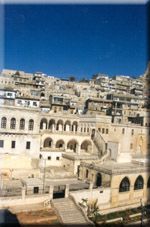 From
a distance, the golden stone houses of Mardin blend into the rock
of the hills on which the city is built. On closer inspection, the stone carving
and decoration of the houses and public buildings reveals the city to be an
architectural treasure-chest. Among the jewels are the ancient citadel and
several mosques, in particular, Ulu Mosque. The 15th-century Kasım Paşa
Medrese is remarkable for its fine stonework. At the lovely Isa
Bey Medrese, from the 14th century, you can admire the magnificently
carved portal and climb to its roof to enjoy a fantastic view of the
Mesopotamian Plain.
From
a distance, the golden stone houses of Mardin blend into the rock
of the hills on which the city is built. On closer inspection, the stone carving
and decoration of the houses and public buildings reveals the city to be an
architectural treasure-chest. Among the jewels are the ancient citadel and
several mosques, in particular, Ulu Mosque. The 15th-century Kasım Paşa
Medrese is remarkable for its fine stonework. At the lovely Isa
Bey Medrese, from the 14th century, you can admire the magnificently
carved portal and climb to its roof to enjoy a fantastic view of the
Mesopotamian Plain.
Only 7 kilometres east of Mardin is the Syriac Jacobite Monastery of Deyrulzaferan, which was once a thriving religious community. At nearby Kızıltepe, the 13th-century Ulu Mosque, one of the best examples of Artukid architecture; has superb mihrab reliefs and a beautiful portal. Midyat, famous for its silver jewellery known as 'telkari', also has many elegant and historic houses. Eighteen kilometres east of town is the active Syriac-Jacobite monastery of Deyrelumur (San Gabriel), which dates from the beginning of the fifth century.
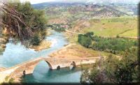
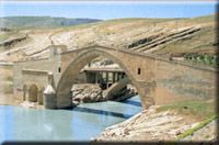
Batman is Turkey's most important oil-producing center, with oil wells pumping the precious fuel dotting the surrounding area. North of Batman, the Malabadi Bridge, built in 1147, spans the Batman River. Undisturbed by time, peaceful waters still reflect the widest single-arch bridge of its day. Two guard towers ensured the bridge's security.
At Hasankeyf are the ruins of the 12th-century capital of the Artukids. The bridge, which once spanned the Dicle and connected the two pans of the city with the ruined palace inside the citadel, evokes the ghosts of a vanished dynasty. The 15th-century Zeynel Bey Mausoleum, attractively decorated with turquoise tiles, reveals Persian influence.
 Siirt
was an especially eminent city at the time of the Abbasid Caliphate. Among the
city's monuments, be sure to visit the 12th century Seljuk Ulu Mosque and the
13th century Asakir Çarşı Mosque. At Aydınlar (Tillo),
only 6 km from Siirt, the Ibrahim Hakkı Mausoleum Complex and
nearby private Ibrahim Hakkı Astronomical Museum are worth a
visit. Siirt produces fine and large pistachio nuts and is known as well for its
excellent goat-hair blankets and kilims.
Siirt
was an especially eminent city at the time of the Abbasid Caliphate. Among the
city's monuments, be sure to visit the 12th century Seljuk Ulu Mosque and the
13th century Asakir Çarşı Mosque. At Aydınlar (Tillo),
only 6 km from Siirt, the Ibrahim Hakkı Mausoleum Complex and
nearby private Ibrahim Hakkı Astronomical Museum are worth a
visit. Siirt produces fine and large pistachio nuts and is known as well for its
excellent goat-hair blankets and kilims.
Şırnak, on the north face of Mt. Cudi (2,114 meters), derives its name from the Moslem belief that Noah's Ark landed on this mountain: Şır - City, Nak - Noah. Forty-five kilometers from Şırnak, Cizre is the supposed location of his tomb.
![]()
Go Back to Archeological Map of Turkey
![]()
Home | Ana
Sayfa | All About Turkey | Turkiye
hakkindaki Hersey | Turkish Road Map
| Historical Places in Adiyaman | Historical
Places in Turkey | Mt.Nemrut | Slide
Shows | Related Links | Guest
Book | Disclaimer | Send a Postcard | Travelers' Stories | Donate a little to help | Getting Around Istanbul | Adiyaman Forum
|
|